In alignment with our commitment to transparency and integrity, we want to clearly disclose that product prices and descriptions may vary on the websites of our retail partners.
We encourage you to visit the retailer's site directly for the most current images, products, prices, and descriptions.
It's important to us that you're informed Zeppy may receive compensation for some listings featured on our site.
Additionally, we want to be upfront about our use of affiliate links; our affiliations, including but not limited to the eBay Partner Network, support our mission to provide valuable content and offerings to you.
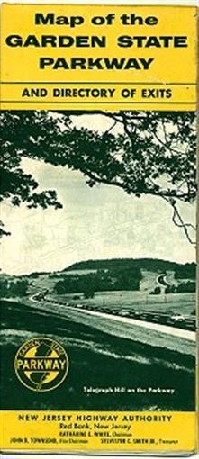
1960 Road Map GARDEN STATE PARKWAY New Jersey 11th Ed.
Handsome fold-out road map of New Jersey's Garden State Parkway, printed more than 48 years ago.
This map opens to 24" x 19" and includes a directory of exits and interchanges, a summary of toll charges, and a message from Governor Robert B. Meyner.
Cartography is by the General Drafting Company of Convent Station, and the map is dated 1960 in the lower margin. It was published by the New Jersey Highway Authority and is identified as the 11th edition.
The illustration on the front cover depicts a view along the Parkway near Telegraph Hill.
The map is in good, lightly used condition, bright and clean, with no rips or tears. We are pleased to offer it with
Disclaimer: Prices and descriptions maybe different on retailers sites, please check the retailers website for the latest images / products / prices and descriptions. Zeppy maybe compensated for some of these listings.
When you click on links to various merchants on this site and make a purchase, this can result in this site earning a commission. Affiliate programs and affiliations include, but are not limited to, the eBay Partner Network.

 Wait a moment... we're getting more products!
 uk
uk  fr
fr de
de es
es it
it us
us ca
ca


